I've changed the address of my photo blog. You should be automatically redirected, but if not here is the new address:
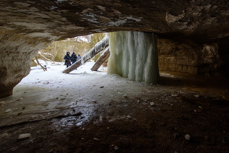
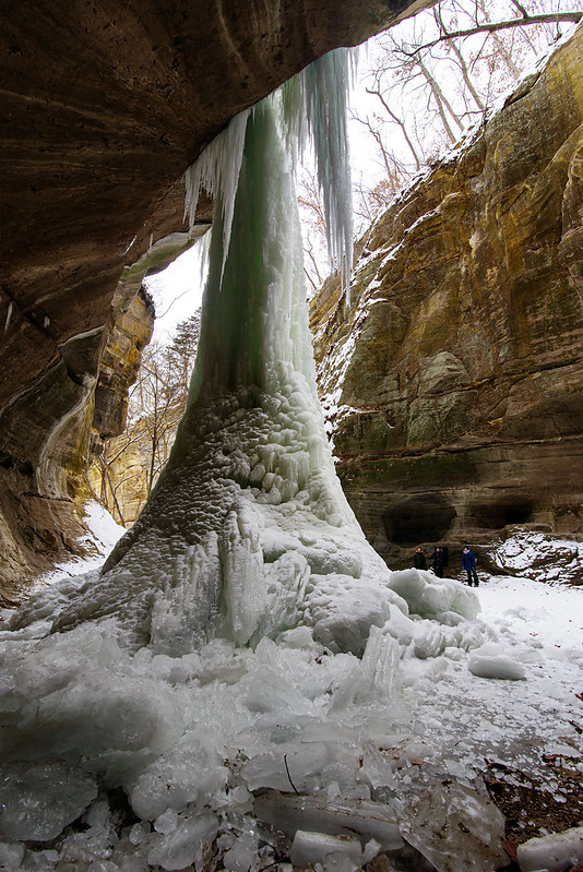
Lake Falls

A full wall of ice just days earlier, Lake Falls is flowing once again thanks to the large amount of meltwater flowing into the lake above the falls. Hiking through Illinois' Matthiessen State Park during winter yields quite a few frozen waterfalls -at least six. On this visit, they were in various stages of melting, some completely gone, and others, half way thawed. The melting increased the amount of water in the upper and lower dells, which in turn, destroyed more of the icefalls.
Not only is the ice melting, but to get to the frozen waterfalls is much more difficult if you wish to stay warm and dry. The paths for at least two of these falls were under at least a foot of flowing water. We decided to visit them anyway, and walked through the cold water; our feet were cold for about 10 minutes as the 35 degree water flooded our boots. But after that, they remained a rather comfortable temperature as our body heat warmed up the water in our boots. Even if our feet stayed cold, it was worth the effort to see these falls once again.
Not only is the ice melting, but to get to the frozen waterfalls is much more difficult if you wish to stay warm and dry. The paths for at least two of these falls were under at least a foot of flowing water. We decided to visit them anyway, and walked through the cold water; our feet were cold for about 10 minutes as the 35 degree water flooded our boots. But after that, they remained a rather comfortable temperature as our body heat warmed up the water in our boots. Even if our feet stayed cold, it was worth the effort to see these falls once again.
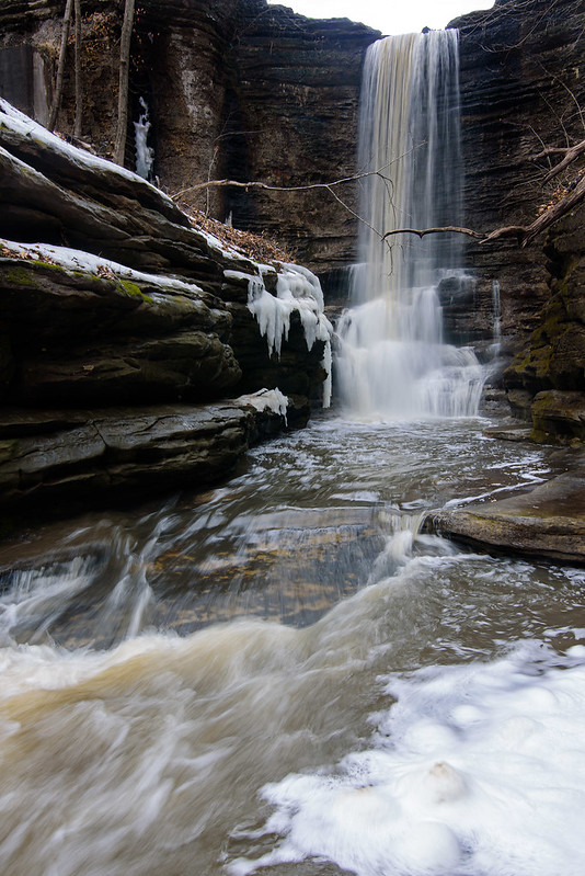
Generally Lake Falls is a bit more accessible, and flows a bit more gentle, but this time we couldn't get too close to the falls without getting ourselves and our gear sprayed with water. Many of the interesting logs that fell into the canyon have disappeared over the years; these were often covered in intricate ice formations, but no longer.
The stream is filled with small cascades of water most only a foot tall like the one in the foreground of the top image. These provide great elements in the landscape, and give so many possible compositions.
I hiked this time without my tripod, so these images, which were taken with a slow shutter of 1/6th of a second, were taken handheld with no support. Without a tripod, it gets a bit tricky to get sharp images at that speed.
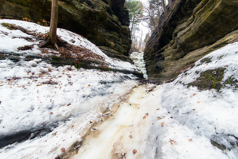
Frozen French Canyon

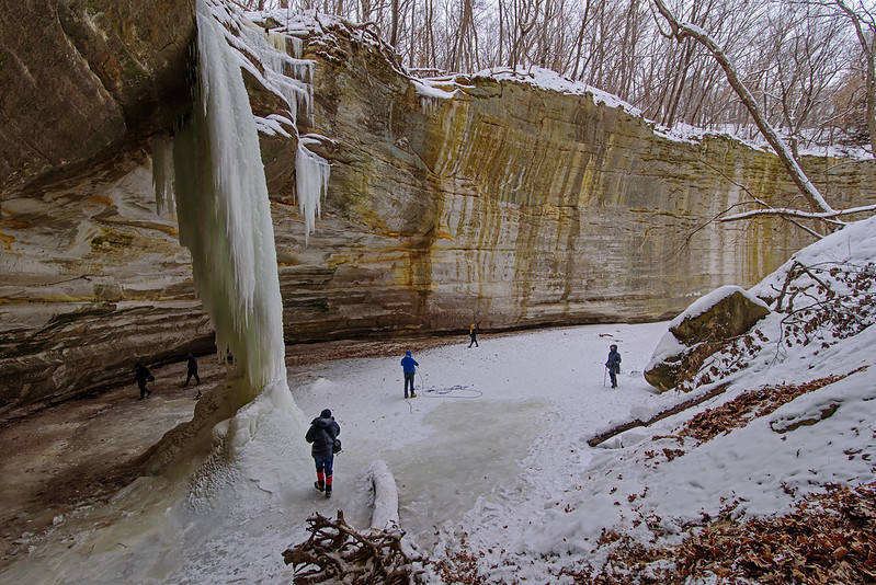
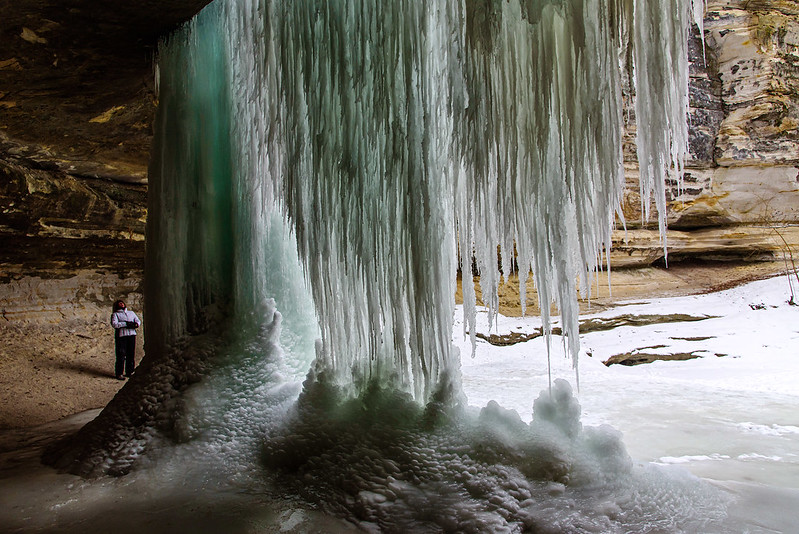
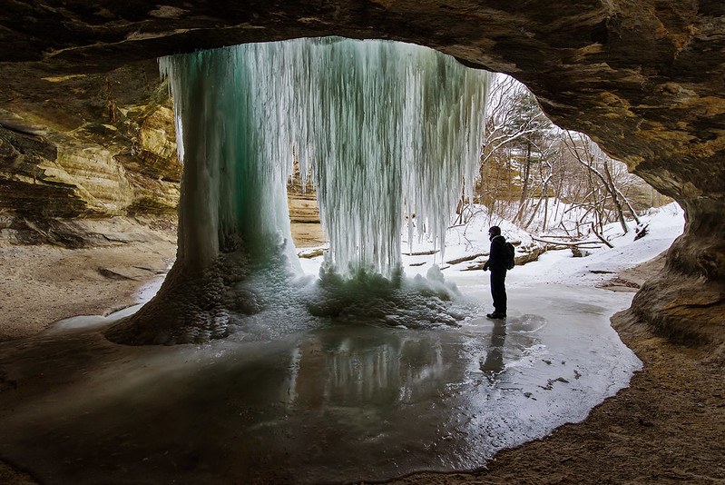
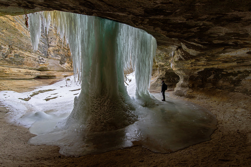
Following a week of warm weather, we decided to visit Starved Rock State Park once again, before all of the frozen waterfalls were melted. On our last trip in the very cold weather, we visited the waterfalls that generally have the most intricate ice formations - knowing they would soon be gone. On this hike, we saw the melting icefalls that we figured would still be somewhat frozen, and we were right.
These waterfalls tend to stay frozen for a bit longer than the fragile falls in LaSalle Canyon because they're thicker and in more shaded canyons. French Canyon is one of those very shady locations and generally doesn't have a huge amount of water flowing into the canyon. A heavy flow of water quickly melts the ice formations, while a more gentle one cascades over, under, or around the ice.
These waterfalls tend to stay frozen for a bit longer than the fragile falls in LaSalle Canyon because they're thicker and in more shaded canyons. French Canyon is one of those very shady locations and generally doesn't have a huge amount of water flowing into the canyon. A heavy flow of water quickly melts the ice formations, while a more gentle one cascades over, under, or around the ice.
This canyon is generally a bit tricky to access when the stream is flowing (if you don't want wet feet), but in winter, it's extremely slippery and difficult to access. Park staff at the visitor's center have told us time and time again that it's not worth even trying to get into French Canyon in the winter - it's too dangerous. The stream flows directly on the portion of the canyon floor that is used for walking, so plenty of ice forms in this area. Without ice cleats on your boots, it's next to impossible to safely walk up into this canyon. Because we've been here many times before, we had our cleats with us.
In the photo above, you can see just how frozen the canyon floor was. No place to hold on to, so you absolutely need ice cleats, and even then, if there is snow on top of the ice, or if the cleats hit rock, you will still slide. I would hate to fall here, not only would you get wet, but you would probably continue sliding 30 or 40 feet down into the pool of water at the entrance to the canyon. I don't know how deep that water is, but you would certainly have a difficult time climbing out, and a very cold walk back to the car.
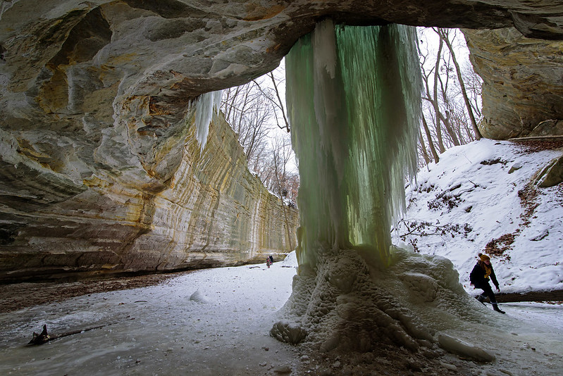
The recent high temperatures has created quite a bit of melt water, in fact, it flooded the canyon and kept us from walking too far in. We were already wet to the knees from walking through the stream at Matthiessen Park, but we weren't too certain how deep this water was, so it was best to keep out of the flooded canyon.
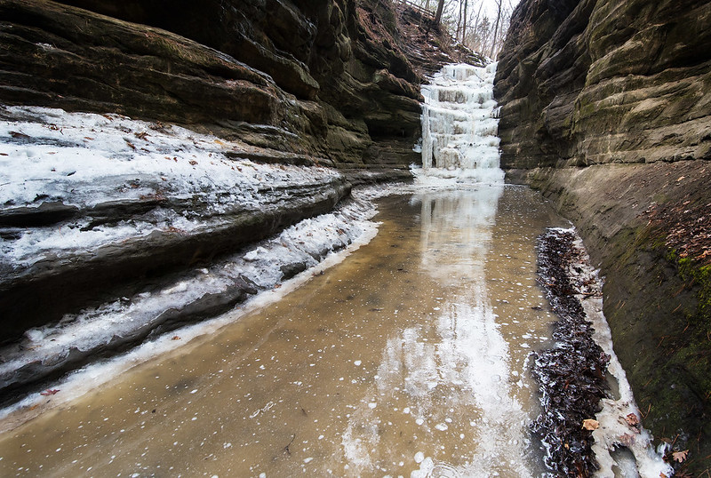
The melt water did allow for some very interesting colors and a nice reflection of the 40 foot tall frozen waterfall. This waterfall doesn't freefall into the canyon, it cascades over the stepped rock formations, so I think it's one of the more interesting waterfalls of the park.
Every day the warm weather eats away at the ice in all 18 canyons of Starved Rock, so if you hope to see some frozen waterfalls, it's best to visit very soon, or you will need to wait until next winter. Bring ice cleats even if you think the trails are clear - you will need them - sometimes into April.
Every day the warm weather eats away at the ice in all 18 canyons of Starved Rock, so if you hope to see some frozen waterfalls, it's best to visit very soon, or you will need to wait until next winter. Bring ice cleats even if you think the trails are clear - you will need them - sometimes into April.
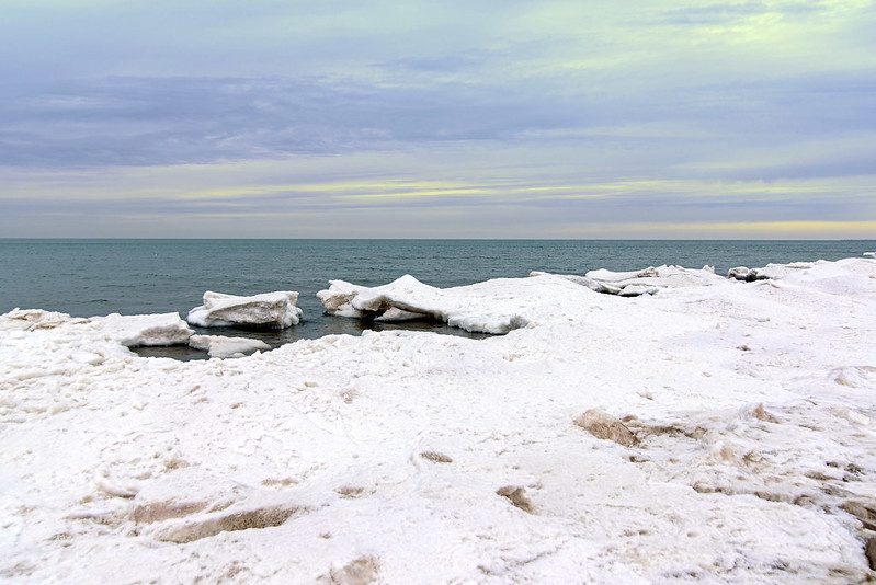
The Thawing Shelf Ice
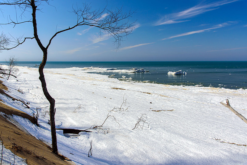
Just a few days earlier, Lake Michigan was filled with ice as far as the eye could see. Last week, we hiked through thigh-deep snow in this same spot to view the ice mounds on the beach, this week, they're almost gone. Only a couple of days of 40 degree weather and the floe ice melts quickly, and soon, all of this ice will be gone as well - it's meteorological spring already.
While our goal was to hike to Kintzele Ditch last week and this week, we approached from a different access this time - Central Beach. Closed for quite some time because of erosion and well water problems with the remodeled washrooms, it's a nice change to access the beach quickly via our old standby trails.
The remnant ice took on the look of the arctic, like small icebergs floating just off shore. But these mounds stood at the bottom of the lake and rose up a few feet above the water.
Some years, these ice mounds can rise 15 feet above the water - as high as the waves can throw the ice chunks when they pound the shore. This year didn't produce the usual number of mounds or ice volcanoes, but it was pretty none-the-less.
Just as it does when the ice forms, when it melts, it creates interesting structures on the beach. This cove is being enlarged little by little as the waves move floe ice into and out of the ice shelf. The beach was lined with similar structures as we hiked the shore to Kintzele Ditch, each unique in size and shape.
My only regret was not having our kayaks- it would be amazing paddling in and out of these small coves near the ice mounds. Maybe next year.
The Snow Covered Trail

Following our walk along the beach, we headed up to an old trail that led to the top of one of the dunes near Kintzele Ditch. An old road leads to the trail, and while the walk is generally easy, our trip this time was a bit more difficult due to the knee-deep snow we needed to move through. Not terribly bad on the flat areas, but up the dune was more strenuous, especially near the top where the snow piled up in tall drifts.

We couldn't imagine not working our way through the snow when we came so far already. Putting out quite a bit of effort in the sunny, 15 degree Fahrenheit weather actually made us sweat. Jackets open, hats and gloves off and we were ready to take on the snowy dune for what I imagined would be a great, winter view of Lake Michigan. We were not disappointed.
Still, even if we didn't make it to the top, just being in the woods after a heavy snowfall was good enough for us.
Hidden Creek

One of our favorite short hikes at the Indiana Dunes National Park is a hike to a small creek between Central Beach and Mt. Baldy. Kintzele Ditch runs between two dunes and empties into Lake Michigan. Its ever-changing path from the foredunes to the lake makes this area a bit hazardous in the winter - one really doesn't know where the creek is, so you can fall through the thin ice into the water. Of course, this creek isn't too deep, so you would only get wet to the knees or so.
Wandering a bit upstream - even with the dunes - can result in a fall into chest-deep water.
With the snowfall we received this February, the creek is mostly hidden under ice and snow. Standing nearby, you can still hear the water flowing by. This year's shelf ice lacks the tall mounds and "ice volcanoes" so the creek doesn't wind through these formations.
Looking toward the woods, it seems as if it would be an easy hike down the center of this valley, but again, we don't trust the ice here. Walking back this way, we would encounter a road not too far away, making the walk back much easier. Instead, we chose to take the more difficult path to enjoy the snowfall one last time before the thaw.
Frozen Kintzele Ditch From the Ground
The heavy snowfall covered the beach and much of the ice covered Kintzele Ditch as it winds through the sand and empties in to Lake Michigan. The view from above couldn't show the depth of the snow and the snow drifts, but the view from the sand shows the snow a bit better.
The creek cuts through the sand and creates a three foot deep cut in the sand, the snow drifted over the ice and cuts, hiding the deeper areas. If one would keep walking, they most likely would end up in snow above their waist! This particular area changes daily sometimes - especially in summer where the waves move the sand and change the direction of the creek. The ice and snow in winter protect the shore from these changes, so for now, Kintzele Ditch will maintain its current flow to Lake Michigan.
Heavy Snowfall on the Lakefront

Two rather large snow storms hit the area along with extremely cold temperatures, turning Lake Michigan into a scene from the arctic.
Our hike began about 1/2 mile away, and once down the slippery dune to the beach, we realized just how much snow actually fell over the past couple of weeks. On average, the snow was past our knees as we made our way toward Kintzele Ditch, in a few places it was shallower, but in others, well past our knees. With all the snow, it was difficult to see exactly where the shore was, so we were careful not to walk out onto the shelf ice. Knowing the area very well, we could estimate and stay safe.
When we reached Kintzele Ditch, it too was iced over and covered in snow. The path of the creek can change daily, so we needed to walk where we knew solid ground was beneath us. If you look closely, you will see our footprints in the snow, walking up to the creek then turning toward the dune. We were able to get to the trail up the dune a bit later. It's an old road that has been abandoned for years, and the snow here was even deeper in spots - up to our pants pockets. That made the walk up pretty difficult and slow, and we questioned if we should try to walk up, but once at the top, we were treated to the scene pictured above. Ice and snow as far as the eye can see on frozen Lake Michigan, and drifted snow all across the dunes and beach. The image is a panoramic image made from three images stitched together.
For a day that started out at zero degrees, it was rather comfortable hiking. No wind at all, full sun, and a lot of strenuous hiking kept us warm enough to open our coats. Temperatures are now climbing up, and soon, quite a bit of this snow will melt; I'm happy we made the attempt before the melt.
Kaskaskia Canyon Icefalls
T This waterfall isn't very tall, but the two logs that were washed down the canyon during some past flood add a lot of interest to the image. Behind the fall is a cave that we usually don't venture into because of the story I heard from a friend who fell through the ice here into the water below that was up past his waist. On this visit, we noticed several other people walking around that area, and with the two weeks of very cold temperatures, we knew the ice was thick enough to support us.

While typically not a canyon for ice climbing, I have seen a few people climbing this icefall in the past, and this year, a family with climbing gear and helmets were approaching was we were leaving. I would think this is a good fall to climb for beginners, and also for experienced climbers who don't have the ability to fasten lines to the trees above. This fall would be challenging enough, and if you did slip, you wouldn't fall 80 feet to the canyon floor.
On To Icy Ottawa Canyon
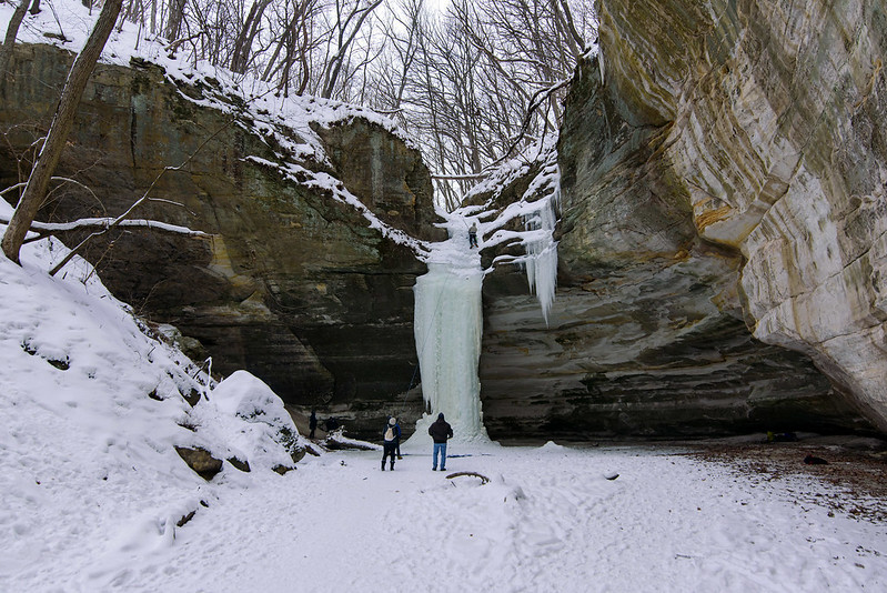
One of the more accessible canyons in Starved Rock State Park, Ottawa Canyon is less than a half mile hike from the parking area. It's also an easy hike very few hills and only a few stairs, so one can expect a lot more visitors - especially on a day as cold as this (5 degrees Fahrenheit). Usually I'm alone in the canyons when it's so cold, except for an ice climber here and there. As we expected, the waterfall in the canyon was a complete column of ice, towering about 50 feet high to the creek above the canyon.
The canyon is undercut, just like it's sister canyon the Council Overhang just a few hundred meters away. This not only allows hiking behind the falls, but creates a very interesting surround of multicolored rock. Unlike quite a few waterfalls in the park where you need to bend down to get behind the falls, this overhang is very tall, giving a feeling of grandeur to the icefall.
As we entered the canyon, we could see an ice climber near the top of the frozen waterfall. Ice climbing is allowed in a few of the canyons, by permit only. It seems to be a growing sport here at Starved Rock - at least anecdotally; I see more and more ice climbers every year. They're interesting to watch, but can often break off the intricate detailed ice that make the icefalls so pretty. I've been lucky over the years, to capture the icefalls before they're damaged. But give the waterfalls a day or two and they often form new intricate patterns on the face of the icefalls.
The Ice Column

Nearby LaSalle Canyon is a relatively square canyon named Tonti. There are two seasonal waterfalls in this canyon, running mostly in the Spring and after rainfall, but in winter, whatever water is present freezes into a dramatic ice column extending 60 feet to the canyon floor. Tonti Canyon is one of four frozen waterfalls at the park where ice climbing is allowed.
This winter, at least at this point, only one of the waterfalls was frozen completely, the other consisted of icicles hanging from the top of the rock wall. Given a few more weeks, this too will become a complete ice column. The shape of this icefall reminds me of the Native American Thunderbird, with the two wings of ice on either side. Given the area's history, this seems to be an annual spiritual reminder of this Native American presence.
This winter, at least at this point, only one of the waterfalls was frozen completely, the other consisted of icicles hanging from the top of the rock wall. Given a few more weeks, this too will become a complete ice column. The shape of this icefall reminds me of the Native American Thunderbird, with the two wings of ice on either side. Given the area's history, this seems to be an annual spiritual reminder of this Native American presence.
As this ice column grows, it occupies more space at the canyon floor, and generally so much that one can't walk behind to see the falls from the back. This year, the column was thin enough at this point to easily walk behind for some images of the 60 foot tall ice fall.
As we explored the frozen waterfall, a group of ice climbers began staging their gear to climb the icefall. Permits are required to climb the waterfalls, and as I found out days later, Tonti Canyon is closed to visitors. We did not see a sign on our way in as we followed the tracks in the snow from LaSalle Canyon, so perhaps the closed notice was outdated on the website.
The Backlit Icefall
Not only was the day very cold, it also lacked sunlight. I'm a rather unusual photographer, I prefer sunlit scenes. In general, most photographers prefer the flat light from an overcast day, it reduces the harsh contrast between bright and dark. But I would rather work through those difficulties while enjoying my time outside.
Sunlight in this case, may have brought out some interesting colors in the ice. The blues of the sky and the greens of the moss would have probably produced some great effects in the backlit ice. But, I will take what I am offered - this scene is how I encountered it, I'm not waiting for the planets to align to capture an image!
It's difficult to tell just how large this waterfall is without some sort of known object near it for some scale. People not only add interest to the image, they offer a sense of scale. That's one of the benefits of hiking with someone, they can be used for scale! Plus, we can compare images later to see each other's take on the same subject.
It looks as if these falls will only get larger in the next week, then perhaps they will take a bit of a beating from the expected 35 degree temperatures next weekend. They certainly won't break apart completely, but they may show some wear. The melt water and rain - if it gets cold again at night - will make the ice grow larger and larger.
The Frozen Waterfall of LaSalle Canyon
Bitter cold has a grip on northern Illinois, giving us high temperatures in the single digits and lows below zero. All this cold begins to change the landscape, and there's often no better change than the waterfalls of Starved Rock State Park turning to ice.
A check of the weather forecast showed another winter storm approaching the area on Monday, so our scheduled trip to Starved Rock was pushed up a day to avoid travel during the snowstorm. That did mean we would be hiking in temperatures only reaching 4 degrees Fahrenheit. We've done it before, and once we get into the canyons, we tend to forget about the cold - except for our hands which are exposed as we photograph the ice formations. Once we're finished with the photos, we move on to the next canyon, which often means walking into the bitter cold wind toward the Illinois River until we turn into the next blind canyon.
The frozen waterfall in LaSalle Canyon is a favorite, and almost never disappoints. The large overhang of the rock allows the water to flow over the opening in the rockface, allowing visitors to walk behind the waterfall. In winter, a sort of ice cave is formed by the falls, and the translucent ice takes on some beautiful colors. Many of the ice caves formed in this manner are in smaller canyons, so venturing behind the ice can be difficult if not impossible, but LaSalle is so large, it never closes up completely.

This ice is constantly changing, no matter how cold the temperature is, water is always flowing inside and around the icefalls. It's interesting to visit a few times in the winter so see just how much the falls change. At times, large chunks of ice fall to the canyon floor, and the process starts all over again. It's always best to stay away from the ice, and not to stand directly beneath it.
Despite the cold, we ran into a few visitors in a few canyons. Only about six people were in LaSalle Canyon during our visit, it's about a mile walk from the nearest parking area, so the freezing temperatures keep out all but the determined and prepared.
Winter Expanse

The lakeshore can be a lonely place during the winter. Not many people visit, and those who do, tend to stay close to the parking areas and simply walk out and take a photo, then walk back. To get the best view of the lake, you need to climb a dune. Most dunes are off limits, but there are a few where visitors are allowed to follow the trails up.

We followed the narrow trail along the ridge of the foredunes to get to the tallest dune in the area. The trail is challenging enough in the summer months, but the ice and snow made it a bit more difficult on this day. The snow also hides the trail in some places, so you have to look ahead to make sure you're still on the correct trail - not that you'll get lost, but to protect the plants growing in the area. This time we were lucky to find another person's foot prints on the trail; maybe a park ranger.
Once at the top, we were treated to the best view of Lake Michigan in the area. I would approximate the height of the dune at 80 to 90 feet, but perhaps it's a bit taller. It's often difficult to tell how high up you are when you see the lake below, things tend to compress visually, but here we could see the ice did not quite go to the horizon, and the Chicago skyline was in the distance across the lake.
From Liquid to Ice in a Matter of Days

Just a week of very cold weather was enough to turn Lake Michigan into something that appears to be in the arctic. The floe ice has gathered at the shore, and some shelf ice "volcanoes" have also formed, transforming the waterscape dramatically. From approximately the same place - just with a different lens - I captured the change the beach has undergone in only a few days.
The image below was taken two weeks prior to the image above (yet actually the beach looked exactly the same one week prior).

Climbing up the trail to the small dune just above the beach, we can see the extent of the ice on the lake. While on the beach it appeared to completely cover Lake Michigan, from this vantage point 75 feet above the beach, open water can be seen on the horizon.
Again, this image was take from the same location as the one below (which was taken two weeks ago), using a different lens. The open water is only a memory until warm temptatures arrive and melt the ice on Lake Michigan.

Not only does the ice look beautiful, it also protects the beach from erosion by the crashing waves of winter storms. Protected by this front line defense of ice, erosion cannot take place. The newly replentished sand of Central Beach has already shown signs of erosion, but that is to be expected in this ever changing landscape. Dunes are the most unstable landforms on earth - according to the famous Henry Cowles who spent the better part of his life studying the biology of this area.
The Indiana Arctic
Not technically, but it sure does look like the Arctic at this time of year. Just seven days before, there wasn't a bit of ice at this location, only cold waves crashing on the beach. A few days of sub freezing weather (including three around zero) and Lake Michigan turns into something from another part of the world. On this morning, we were treated to bright sunshine, which illuminates the flow ice, contrasting it against the dark sky. More snow was on its way later in the day, and the approaching clouds can be seen on the horizon.
This is the point at Lakeview Beach Access, part of the Indiana Dunes National Park. It's the easiest access to view the beach - especially in winter. Park your car, and walk about 60 feet to the rail that overlooks Lake Michigan. This year, the path down to the beach is closed, so the view is limited to the patio area, you can't venture down to the sand. Before stopping here, we walked along the beach from the Dunbar Access to enjoy the ice close up. As we arrived at this point, we dared not go any further, erosion has eaten away at the sand on the point, so we weren't going to gamble and walk on the shelf ice. We walked back and drove up later - only to find the beach access was closed. Good thing we walked a few block on the frozen beach.

The view from the Lakeview Access patio is elevated, giving a higher vantage point of the icy lake, but a bit obstructed by trees. One of the better views is just down the path to the right, where you can look almost all the way to Central Beach - about 2 miles down the shore. That would be our next stop; Central beach is finally open after a long period of closure due to erosion and washroom renovations. The climb down to the beach at Central Beach is steep, and the climb up, is much more challenging. This will be corrected by waves over the winter, and bulldozers in the spring. Still, it's certainly worth the effort to view the beach in winter.
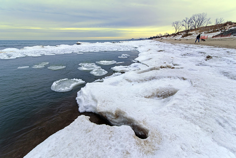
Surrounded by Ice

One week ago, Lake Michigan was liquid as far as the eye could see. Only a small amount of ice was seen along the shore, and it barely extended five feet out into the water. In only a few days, the ice has formed, and extends almost as far as the eye can see. This can happen rather quickly, but usually begins in January and takes a few weeks before Lake Michigan take on the look of the arctic.
Temperatures overnight were down to 2 degrees above zero Fahrenheit, and by this time in the morning, they climbed all the way up to 8 degrees! This was the beginning of our hike on the Lake Michigan shore, we ultimately hiked 5 miles total on three beaches. Surprisingly, dressed appropriately, we were quite comfortable.

The pier was very icy from last week's winter storm, so we were unable to venture any closer. At least that's what the signs told us, so we didn't bother to test if anyone would come out to tell us to get off the pier. We were not only dressed for the weather, but we also wore spikes on our boots to dig into the ice to prevent us from slipping. As I've done for many years, we could have walked all the way to the lighthouse safely, but the cameras on the pier may have falsely alerted the officials, so we figured it was best to stay off.
Still, there's something about the hike to the end of the icy pier that attracts me to the lakeshore every winter. If you haven't been to the shore of Lake Michigan in the dead of winter, make this the year you start the tradition. There are many areas where you can safely bring the entire family to view the frozen lake, some only 100 feet from the parking lot. We enjoy these access points too, but if you get down to the beach and hike a mile or two on the shoreline (on the sand NOT on the ice), you will be treated to a lonely, barren, beautiful landscape that is unlike anything you've experienced. And, most times you will not encounter another person in your entire field of vision, so stop, look around, and listen, take it all in.
Building Shelf Ice

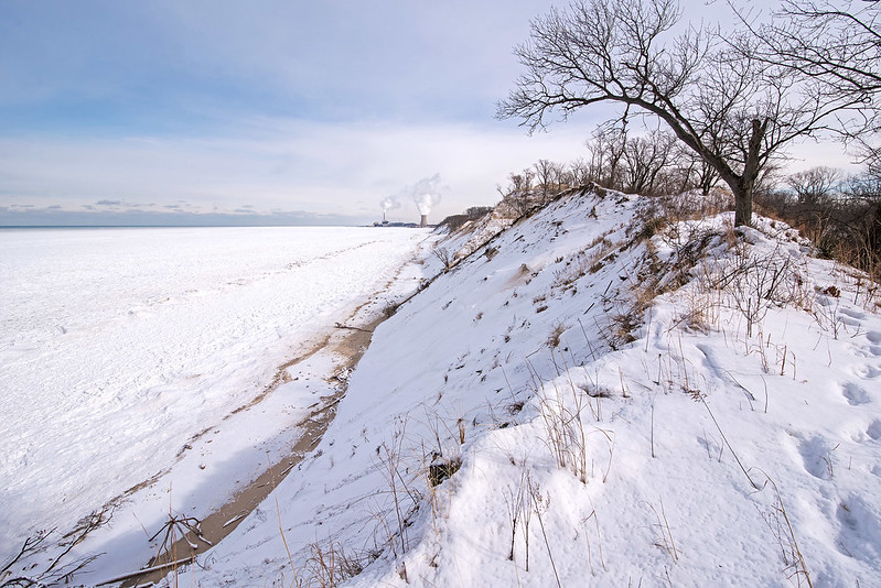
Temperatures have finally dropped enough to begin the ice building process on the shore of Lake Michigan. While only in the 20's, the ice still builds slowly, but later this week, temperatures are expected to drop to single digit highs - perfect for building plenty of ice! Climbing a bit up the dunes for a better view of the beach, you can see the extent of the shelf ice along the shore. It hasn't extended into the lake very much, but from this 30 foot tall dune, you get a different perspective of the shore.

Lower down on the beach, the details of the ice are more evident. We were lucky enough to visit at the early stages, so we could actually walk out a bit on some of this ice. You can actually see the shore to the right, meaning this ice was formed when there were high waves, and the ice was deposited a bit above the normal waterline. If the ice extends any further, we wouldn't dream of walking on it.
The Shelf Ice Begins to Form
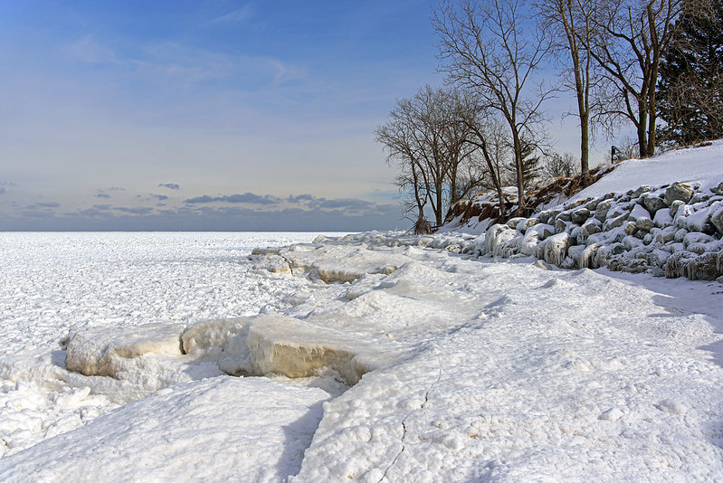
After quite some time, Lake Michigan has finally gotten cold enough for shelf ice to begin forming on the Indiana shore. Just a few miles north of this beach, there was no ice to be seen, but here, on the southern edge of the lake, it has begun. It's possible that the winds push any thin ice floes toward the southern shore, and it gathers here first.
Here as the ice begins to form, you can see shelf ice (the ice that attaches to the shoreline that can build tall mounds over time), floe ice (the ice pieces floating in the water), and pancake ice (round formations of floating ice that are created by the constant bumping around of the chunks of ice). This is a great time to see just how these formations are created, and it's still safe to go near the shore. While it's never safe to venture out onto the shelf ice, here, the shelf ice is still mainly only hills of ice on the sand that touch the water. However, the ice that is in the water - even if it seems to be sitting on the bottom of the lake - can be very dangerous to walk on. Stay off!
Here as the ice begins to form, you can see shelf ice (the ice that attaches to the shoreline that can build tall mounds over time), floe ice (the ice pieces floating in the water), and pancake ice (round formations of floating ice that are created by the constant bumping around of the chunks of ice). This is a great time to see just how these formations are created, and it's still safe to go near the shore. While it's never safe to venture out onto the shelf ice, here, the shelf ice is still mainly only hills of ice on the sand that touch the water. However, the ice that is in the water - even if it seems to be sitting on the bottom of the lake - can be very dangerous to walk on. Stay off!
Even though the ice is just forming, there are still large chunks of ice out in the lake, and many of them are beautiful on their own. It will be interesting to watch these formations grow and change over the next few weeks. If the temperatures remain below freezing, and the winds keep pushing the waves and ice toward the shore, the shelf ice can grow relatively fast. High waves will pile the ice up to 10 or 15 feet in hight, creating ice volcanoes, cone-shaped mounds where the center is hollow and water is able to push ice to the surface where it piles up - similar physics as a volcano mound. After a few weeks, these ice fields can extend hundreds of feet into Lake Michigan. Coupled with floe ice and more storms, they can reach as far as the eye can see, making a beautiful arctic scene right here in the Midwest.
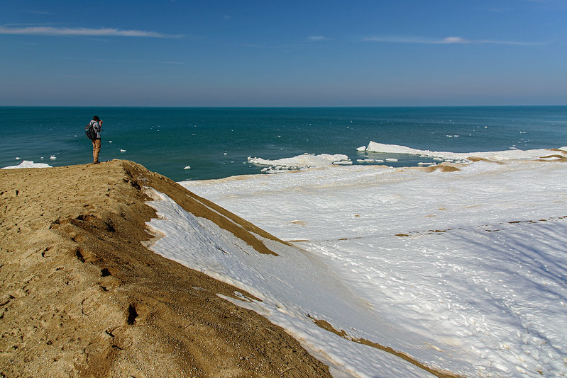
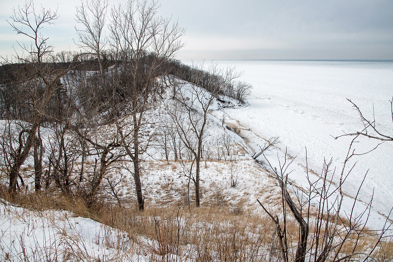
Dimple Dune
At the very end of Central Beach, a relatively tall dune stands guard over Lake Michigan. Dimple Dune offers one of the best views of the entire beach, mostly because of its location. Most of the dunes in the park are closed to hiking, and the paths are well marked "keep off," but this dune has an old road system behind it, making it relatively easy to access without damaging any plants or dunes. Climbing on the loose sand of a blowout (portion of a dune with no vegetation that has eroded away) can accelerate the erotion process, so we always stay clear of such areas. Even when hiking a marked trail, we make sure not to step on any plants - marram grass does not tolerate trampling.
From Dimple Dune, one can see many miles across Lake Michigan, including the Chicago skyline, and even into Michigan. Looking behind the dune, the vast areas of LaPorte and Porter Counties can be seen high above the treetops. Several old homes used to stand in this area, along with a few streets that are still evident today. The homes were razed just a few years back; I can only imagine being lucky enough to live right on these dunes.

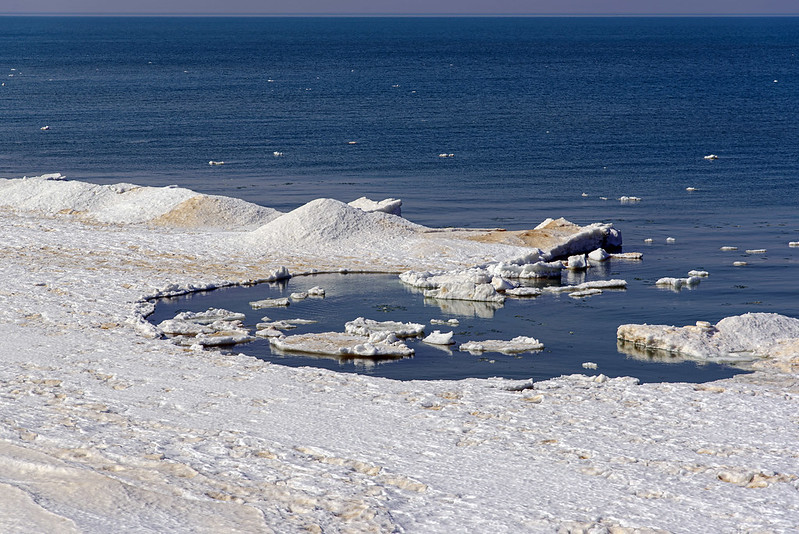
Looking down onto the beach, we can see where we stood just moments prior, on the frozen shore of the small cove filled with logs, boulders, and ice. It appears rather small from this height, but those trees are full size, some over 40 feet in height. Looking at the top photo on this post, for a sense of scale, look along the beach in the shadow of the dune toward the top of the photo, you will see two people walking on the beach. Their size should give you an idea of the size of the sand dunes along this shore of Lake Michigan.
Subscribe to:
Posts (Atom)


